PREVIOUS
✖
Monsoon and early predictions
August 26 , 2019
2514 days
5849
0
The story so far
- The southwest monsoon made a late entry into Kerala on June 7, after a delay of nearly a week. However, things haven’t looked rosy.
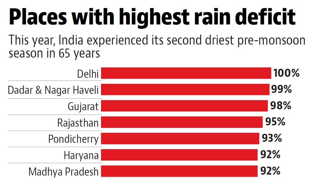
- With India having posted its lowest pre-monsoon rain from November 2018 to March 2019, reservoirs were depleted and a good monsoon was necessary.
- As of June 27, India got only slightly more than two-thirds of rain it normally gets in this month.
- Many places, including Chennai, are in the grip of a water crisis and about 80% of the country’s meteorological divisions have registered deficient rainfall.
- But recently, the monsoon has left a trail of destruction in Maharashtra, Kerala, Karnataka in the south.
- Assam and Bihar struck into grave flood and Himachal Pradesh breaks 70 years record, receives highest ever rainfall in 24 hours.
Prediction for the months
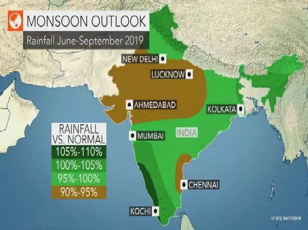
- July and August are most important for the monsoon and contribute nearly 66% of the 89 cm of rainfall that India gets from June-September.
- This year, the India Meteorological Department (IMD) had forecast in May that July rainfall would be 95% of what it usually gets and August 99% of its normal.
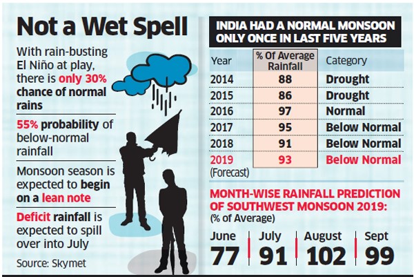
- These numbers were calculated on the assumption, in April, that an El Niño- characterised by a warming of the Central Pacific Ocean-that seemed to be visible on the horizon, would slowly lose steam.
- An El Niño is generally associated with a weakening of monsoon rains in India though there are several other climatological factors that too could cause a drying up of monsoon rains.
- In May, the IMD said India would get ‘normal’ rains from June-September.
- The agency, however, refrains from giving a specific forecast for the month of June.
- Historically, there’s no correlation between the amount of rainfall in June to what lies in the month ahead.
- Cyclone Vayu that formed in the Arabian Sea and threatened Gujarat was a major hurdle to the progress of the monsoon, as is, currently, a Western disturbance — a rain-bearing system that passes over Pakistan, Jammu Kashmir and parts of north India — that is obstructing monsoonal currents.
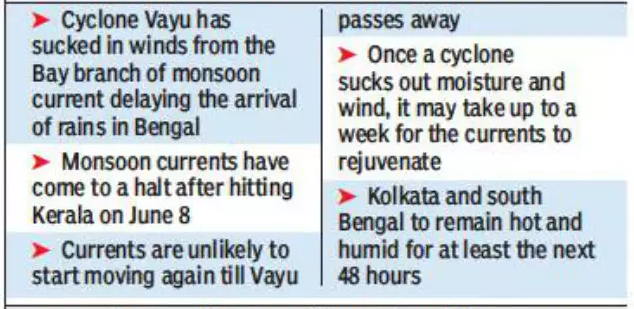
- The delayed progress of the monsoon, that is causing national consternation, is largely due to the laggard branch of the monsoon that begins in Kerala and travels upwards along the western coast.
- The monsoon branch that enters eastern India, around the same time as the southern branch, is relatively better performing thanks to convective currents formed in the Bay of Bengal.
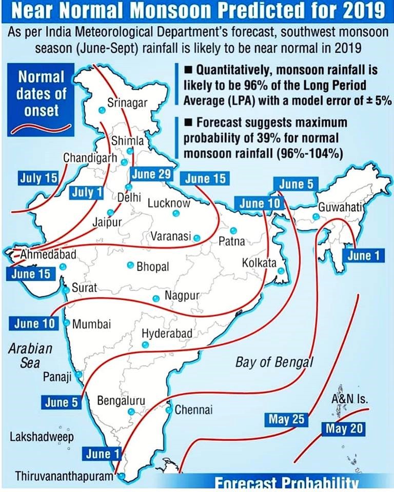
Spread of monsoon in the country
- The monsoon has covered the whole of south as well as eastern India.
- By July 15 the monsoon should have ideally covered its last outpost in western Rajasthan, but this is unlikely given the delay in the monsoon’s advent.
- In the week ahead, it’s expected to make further inroads into central India and most of Gujarat and Uttar Pradesh, but it is not happened.
- However, the geographic spread obscures the quantity of rain.
- Only two of India’s 36 meteorological subdivisions have posted normal rainfall and 27 of them are grappling with deficient rainfall.
- By June 30, a low-pressure pulse is expected to form over the Bay of Bengal and give a significant push to the monsoon, but such a pulse was not occurred.
Monsoon forecast methods
- Until about the 2010, the only method employed by the IMD to forecast the monsoon was statistical models.
- These essentially involved identifying climate parameters linked to the performance of the monsoon — for instance, the sea surface temperature gradient between North Atlantic and North Pacific, the volume of warm water in the equatorial Pacific, the Eurasian snow cover.
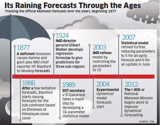
- Their values in February and March are correlated to values of actual rainfall over a hundred years and then, using statistical techniques, extrapolated to forecast a particular year’s monsoon.
- This has, however, proved wrong and the IMD missed its mark on forecasting major droughts and rain-deficits — particularly 2002, 2004 and 2006.
- The IMD responded by finding new parameters but keeping the technique essentially the same.
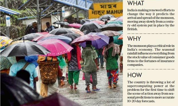
- Only around 2015 did it start testing a dynamical system.
- This simulates the weather at a chosen set of locations on a given day - the land and ocean temperature, moisture, windspeeds at various heights, etc - and powerful computers calculate how these weather variables will change over days, weeks, months.
- It's able to do this by solving physics equations that show how each of these weather variables is related to each other.
- Though meteorological agencies around the world are shifting to such techniques, they still aren’t considered entirely reliable for forecasting the monsoon.
- The IMD and several private weather agencies are increasingly relying on more sophisticated and high-resolution computer models to give localised forecasts, or warn farmers of changes in weather 10-15 days ahead.
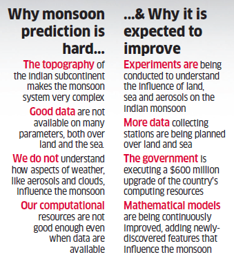
- Rather than long-range forecasts that only give a broad tenuous picture of the likely performance of the monsoon, these shorter forecasts are far more reliable and help farmers make decisions about sowing.
- These models are also useful for anticipating heat-wave or a cold-wave and therefore useful to urban planners and government.
- The statistical model continues to be the bedrock of the IMD’s forecast philosophy but its days are numbered.
Monsoon and India’s water crisis
- India’s water crisis, according to experts, is due to over-extraction of groundwater resources and not enough storage of rain water and surface water.
- The Central Water Commission, in its recommendation of how reservoirs should store and release water assumes that reservoirs will be empty on June 1 and gradually refill over the course of the monsoon, and be available for the non-monsoon months.
- Given that June contributes only 17cm or about 20% of the monsoon rainfall and is known to progress in spurts, farmers have already delayed sowing and relying on crop varieties that grow relatively quickly.
- Moreover, several farmers plant intensely water-guzzling crops that aren’t suited to their climate or prevalent water table.
- While a July rainfall can temporarily alleviate parched ground, it can’t solve the graver crisis of depleting groundwater and insufficiently charged aquifers.
- - - - - - - - - - - - - - -

Leave a Reply
Your Comment is awaiting moderation.