PREVIOUS
✖
Bow Echos in Delhi
June 4 , 2025
2 days
87
0
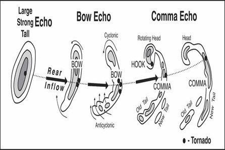
- The intense storm that hit Delhi has appeared in an unusual shape in the India Meteorological Department’s (IMD’s) weather radar imagery.
- The storm was looked like a crescent or an archer’s bow.
- In technical terms, such presentations of storms are called “bow echoes”.
- The bow echoes because they are very often a precursor to the more destructive windstorms.
- A bow echo can extend from 20 km to 100 km, and last between three and six hours.
- The term was first coined in the 1970s by Ted Fujita, a Japanese American meteorologist known for developing the scale to classify tornadoes.
- When rain-cooled air comes down to the ground and spreads out horizontally.
- As this happens, a boundary called the gust front is created between the rain-cooled air and warm-moist air on the surface.
- This front pushes up the warm-moist air into the atmosphere, which forms new thunderstorms.
- These new thunderstorms produce more rain, thereby creating more rain-cooled air, which helps the gust front to maintain its strength.
- As this process keeps repeating itself, there comes a point when there is an inflow of air on the trailing side of the line of storms and bends it like an archer’s bow.
- The cycle lasts as long as new thunderstorms keep forming at the front, helping the system grow and move forward with strong winds.

Leave a Reply
Your Comment is awaiting moderation.