PREVIOUS
✖
Climate Vulnerability Index
March 17 , 2019
2657 days
1531
0
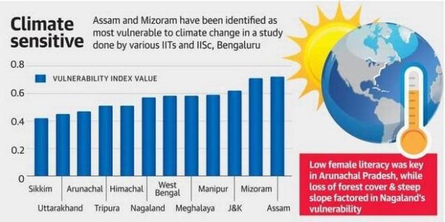
- Indian scientists and researchers in collaboration with state authorities prepared a ‘vulnerability index’ of the 12 Himalayan states based on district-level data.
- The target was to evolve a common methodology, and determine how districts there are equipped to deal with the vagaries of climate change.
- Vulnerability would be a measure of the inherent risks a district faces, primarily by virtue of its geography and socio-economic situation.
- Eight key parameters on the basis of which a vulnerability score could be generated are
| Percentage of Forest Cover | Yield variability of food grain |
| Area under slope >30% | Average-man days under MGNREGA scheme |
| Population density | IMR Rate |
| Female literacy | Percentage of BPL Families |
- On a scale ranging 0-1, 1 indicating the highest possible level of vulnerability, at the top of the scale were Assam with a score of 0.72 and Mizoram at 0.71.
- The Department of Science and Technology eventually plans to have a climate portal for all the states, whereby users can zoom it on any district in the country and get a sense of what kind of risks in Climate and Socio-economic are present.

Leave a Reply
Your Comment is awaiting moderation.